The address used to geocode the risk (that is, place the risk spatially).
Match Type
Identifies the geocoder match-type value:
-
Parcel Level — The most accurate match available: the property is within an identified parcel in the parcel database.
-
Address Level — A good match: both the corresponding street segment and address range are in the street database.
-
Street Level — A close match: the corresponding street, but not the address range, is in the street database.
-
ZIP Code Level — The corresponding street is not in the street files. The system places the address at the center of the appropriate ZIP Code.
100-Year Loss Risk Level
The loss amount that has a 1 percent chance of being equaled or exceeded in any given year (or is likely to be equaled or exceeded in 1 year out of every 100). The risk level is expressed as a percentage of the value of the property in ranges from 0 percent to 100 percent.
![]() Example: If the 100-year loss level is 20 to 25, there is a 1 percent chance in any given year that losses will equal or exceed 20 to 25 percent of the total value.
Example: If the 100-year loss level is 20 to 25, there is a 1 percent chance in any given year that losses will equal or exceed 20 to 25 percent of the total value.
250-Year Loss Risk Level
The loss amount that has a 0.4 percent chance of being equaled or exceeded in any given year (or is likely to be equaled or exceeded in 1 year out of every 250). The risk level is expressed as a percentage of the value of the property in ranges from 0 percent to 100 percent.
![]() Example: If the 250-year loss level is 20 to 25, there is a 0.4 percent chance in any given year that losses will equal or exceed 20 to 25 percent of the total value.
Example: If the 250-year loss level is 20 to 25, there is a 0.4 percent chance in any given year that losses will equal or exceed 20 to 25 percent of the total value.
Average Annual Loss
The average loss expected to occur per year over a period of many years. The risk level is expressed as a percentage of the value of the property in ranges from 0 percent to >2 percent.
Relative Risk within State
A ranking of a property's risk score relative to other properties within the same state, expressed in percentiles from 0 to 100.
![]() Example: If the relative risk level for a property is 70 to 80, then 70 to 80 percent of the properties in the state have the same or lower average annual risk level.
Example: If the relative risk level for a property is 70 to 80, then 70 to 80 percent of the properties in the state have the same or lower average annual risk level.
Relative Risk within County
A ranking of a property's risk score relative to other properties within the same county, expressed in percentiles from 0 to 100.
![]() Example: If the relative risk level for a property is 70 to 80, then 70 to 80 percent of the properties in the county have the same or lower average annual risk level.
Example: If the relative risk level for a property is 70 to 80, then 70 to 80 percent of the properties in the county have the same or lower average annual risk level.
Hurricane-Specific Values
Click here to view Hurricane Profile sample report.
Storm Surge Potential
Identifies whether there is a potential for an abnormal rise in sea level accompanying a hurricane or other intense storm.
Distance to Effective Coast
A property’s distance in miles to the AIR-calculated effective coast, part of a modeled coastline that indicates where a hurricane’s behavior is likely to change from what it does over water to what it does over land. The information is valuable when determining a location’s exposure to the hurricane peril, because the distance helps predict how wind speeds are likely to behave near a particular section of the coastline. For example, a location in a wooded or highly developed section of the coastline might experience a lower wind speed than another location in a flat or open area of the coastline, even if the two locations are the same distance from the actual coastline.
Distance to Actual Coast
A property’s distance in miles to the actual physical coast. This easily measured distance is often useful for underwriting. Hurricanes usually lose strength as they travel inland. Therefore, a property’s distance to the coast is important in determining the potential hazard.
Coastal County
An indication of whether the property’s county abuts the coast. The service returns these values:
Yes — The property is in a county that abuts the coast.
No — The property is not in a county that abuts the coast.
Elevation
Identifies the elevation of the location from the mean sea level, in feet. Displays elevation in ranges from less than 5 feet to more than 1,000 feet above mean sea level.
Terrain/Land Use
Provides a description of the type of terrain or land surrounding the location. Terrain can have a significant effect on wind speeds.
High-Velocity Wind Region
An indication of whether the property is near an area prone to high-velocity winds. The service returns these values:
Yes — The property is in an area prone to high-velocity winds.
No — The property is not in an area prone to high-velocity winds.
(This data element is available in Florida only.)
Exposure Area
Categorizes the property’s area using zones based on surface terrain. The service returns these values:
B — Urban and suburban areas, wooded areas, or other areas with numerous closely spaced obstructions the size of single-family dwellings or larger.
C — Open terrain with scattered obstructions having heights generally less than 30 feet. The category includes flat, open country; grasslands; and shorelines in hurricane-prone regions.
(This data element is available in Florida only.)
An indication of whether the property’s location is in a zone subject to wind-borne debris. The service returns these values:
Yes — The property is in an area prone to wind-borne debris.
No — The property is not in an area prone to wind-borne debris.
(This data element is available in Florida only.)
An indication of the wind speed associated with historical hurricanes that occurred in the zone where the property is located. The service returns these values, in miles per hour:
(This data element is available in Florida only.)
Earthquake-Specific Values
Click here to view Earthquake Profile sample report.
CA DOI Zone
Specifies the property’s zone as assigned by the California Department of Insurance (Applies to properties in California only.)
Liquefaction Potential
The potential (described as very high, high, moderate, low, or very low) for liquefaction to occur at a location.
This phenomenon occurs during severe ground shaking in which saturated soils — usually loose sands — lose their bearing capacity and become liquid.
Landslide Zone
Identifies whether the location is inside or outside a landslide zone. (Available in California only.)
Fault Zone
Identifies if the location is inside or outside an Alquist-Priolo fault rupture zone.
Soil Type
Indicates the soil type under a structure. The underlying soil type may have a determining effect on potential earthquake damage to structures.
|
SOIL ID |
VALUE |
|
1 |
Very hard rock |
|
2 |
Hard rock |
|
3 |
Soft to firm rock |
|
4 |
Stiff clay and sandy soil |
|
5 |
Soft soil (shallow soil) |
|
6 |
Firm to hard rock |
|
7 |
Soft rock |
|
8 |
Soft soil to firm soil |
|
9 |
Soft soil (soft soil and bay mud) |
|
10 |
Water |
|
11 |
Data not available |
Here are definitions of the soil types:
Very hard rock (crystalline rocks with small fractures) — metamorphic rocks with very widely spaced fractures and an average shear-wave velocity of 1,620 meters/second (m/s)
Hard rock — between National Earthquake Hazards Reduction Program (NEHRP) site classes A and B and with an average shear-wave velocity of 1,150 m/s
Soft to firm rock (gravelly soil and soft rock) — soft igneous and sedimentary rocks, sandstones, shales, gravels, and soils with more than 20 percent gravel and an average shear-wave velocity of 540 m/s
Stiff clay and sandy soil (firm soil) — loose to very dense sands, silt loams, and sandy clays and medium-stiff to hard clays and silty clays with an average shear-wave velocity of 330 m/s
Soft soil (shallow soil) — loose submerged fills and very soft to soft clays and silty clays with an average shear-wave velocity of 160 m/s
Firm to hard rock — granites, igneous rocks, conglomerates, sandstones, and shales with close to widely spaced fractures and an average shear-wave velocity of 1,050 m/s
Soft rock (gravelly and stiff soil) — between NEHRP site classes C and D and with an average shear-wave velocity of 370 m/s
Soft soil to firm soil (silty clay and sand) — between NEHRP site classes D and E and with an average shear-wave velocity of 280 m/s
Soft soil (soft soil and bay mud) — loose submerged fills and very soft to soft clays and silty clays with an average shear-wave velocity of 160 m/s
Modified Mercalli Intensity Values (MMI)
Provides information on the intensity of a possible earthquake in the area. Represents Modified Mercalli Intensity (MMI) values in two ways:
Intensity by Probability of Exceedance (PE) — For MMI values VI through VII, gives the probability (in percentages from 0 to 100) that at least one earthquake of the indicated MMI value will occur within the next 30 years.
Intensity by Return Period — For return periods of 100, 200, 250, and 475 years, gives the maximum MMI value of a probable earthquake. Gives MMI values from III to XII.
|
I |
People do not feel any movement. |
|
II |
A few people might notice movement if they are at rest and/or on the upper floors of tall buildings. |
|
III |
Many people indoors feel movement. Hanging objects swing back and forth. People outdoors might not realize an earthquake is occurring. |
|
IV |
Most people indoors feel movement. Hanging objects swing. Dishes, windows, and doors rattle. The earthquake feels like a heavy truck hitting the walls. A few people outdoors may feel movement. Parked cars rock. |
|
V |
Almost everyone feels movement. Sleeping people are awakened. Doors swing open or close. Dishes are broken. Pictures on the wall move. Small objects move or are turned over. Trees might shake. Liquids might spill out of open containers. |
|
VI |
Everyone feels movement. People have trouble walking. Objects fall from shelves. Pictures fall off walls. Furniture moves. Plaster in walls might crack. Trees and bushes shake. Damage is slight in poorly built buildings. No structural damage. |
|
VII |
People have difficulty standing. Drivers feel their cars shaking. Some furniture breaks. Loose bricks fall from buildings. Damage is slight to moderate in well-built buildings, considerable in poorly built buildings. |
|
VIII |
Drivers have trouble steering. Houses not bolted down might shift on their foundations. Tall structures such as towers and chimneys might twist and fall. Well-built buildings suffer slight damage. Poorly built structures suffer severe damage. Tree branches break. Hillsides might crack if the ground is wet. Water levels in wells might change. |
|
IX |
Well-built buildings suffer considerable damage. Houses not bolted down move off their foundations. Some underground pipes are broken. The ground cracks. Reservoirs suffer serious damage. |
|
X |
Most buildings and their foundations are destroyed. Some bridges are destroyed. Dams are seriously damaged. Large landslides occur. Water is thrown on the banks of canals, rivers, and lakes. The ground cracks in large areas. Railroad tracks are bent slightly. |
|
XI |
Most buildings collapse. Some bridges are destroyed. Large cracks appear in the ground. Underground pipelines are destroyed. Railroad tracks are badly bent. |
|
XII |
Almost everything is destroyed. Objects are thrown into the air. The ground moves in waves or ripples. Large amounts of rock may move. |
Distance to Significant Fault
The distance of the location to the nearest significant fault. The distance is provided in ranges.
Severe Thunderstorm-Specific Values
Click here to view Thunderstorm Profile sample report.
Tornado Hazard Information
The likelihood (described as very high, high, moderate, low, or very low) of a tornado affecting the entered address.
Hail Storm Hazard Information
The likelihood (described as very high, high, moderate, low, or very low) of a hail storm affecting the entered address.
Straight-line Wind Storm Hazard Information
The likelihood (described as very high, high, moderate, low, or very low) of a straight-line wind storm affecting the entered address.
Straight-line wind storms are localized wind events with wind speeds of more than 58 mph.
Intensity
Indicates intensity values for three types of storms — tornadoes, hailstorms, and straight-line windstorms
| Storm Type | Possible Intensity Values |
|
Tornadoes |
Fujita Scale intensities: |
|
|
|
|
Fujita Scale |
Wind Speed (mph) |
Damage |
| F-0 | 40 – 72 | Light | |
| F-1 | 73 – 112 | Moderate | |
| F-2 | 113 – 157 | Considerable | |
| F-3 | 158 – 206 | Severe | |
| F-4 | 207 – 260 | Devastating | |
| F-5 | 261 – 318 | Incredible | |
|
Hailstorms |
Size of hailstones in inches: |
|
|
| <0.8 | 1.3-2.0 | 3.0>4.0 | |
| 0.8-1.3 | 2.0-3.0 | >=4 | |
|
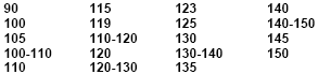
Straight-Line Windstorms |
Wind speeds in miles per hour: |
||
| 0-30 | 70-80 | 120-130 | |
| 30-40 | 80-90 | 130-140 | |
| 40-50 | 90-100 | 140-150 | |
| 50-60 | 100-110 | 150-160 | |
| 60-70 | 110-120 | >=150 | |
Winter Storm-Specific Values
Click here to view Winterstorm Profile sample report.
Hazard Information
The likelihood (described as very high, high, moderate, low, or very low) of a winter storm with damaging wind or snow affecting the entered address.
Flood-Specific Values
Click here to view Flood Profile sample report.
Flood Zone
The flood zone for the property, based on definitions provided by FEMA. Indicates whether the property is in a flood zone and the type of zone.
|
Flood Zone Value |
Description |
| Outside Flood Zone | Outside of a flood zone |
| 100-Year | Within a 100-year flood zone |
| 500-Year | Within a 500-year flood zone |
| Water Body | Very close to the water |
| No Data | Flood information unknown |
FEMA Flood Zone
|
Zone |
Definition |
|
100IC |
The flood insurance rate zone corresponding to areas of the 100-year floodplain where flooding is contained within banks of a channel and the channel is too narrow to show to scale. An arbitrary channel width of 3 meters is shown on the flood map in the report. |
|
500IC |
The flood insurance rate zone corresponding to areas of the 500-year floodplain where flooding is contained within banks of a channel and the channel is too narrow to show to scale. An arbitrary channel width of 3 meters is shown on the flood map in the report. |
|
A |
The flood insurance rate zone corresponding to the 100-year floodplains determined by approximate methods in a Flood Insurance Study. |
|
A99 |
The flood insurance rate zone corresponding to areas of the 100-year floodplain that will be protected by a federal flood-protection system where construction has reached specified statutory milestones. |
|
AE |
The flood insurance rate zone corresponding to the 100-year floodplain determined by detailed methods in a Flood Insurance Study. |
|
AH |
The flood insurance rate zone corresponding to areas of 100-year shallow flooding, with a constant water-surface elevation (usually areas of ponding), where average depths are between one and three feet. |
|
ANI |
An area located within a community or county not mapped on any published Flood Insurance Rate Map (FIRM). |
|
AO |
The flood insurance rate zone corresponding to the areas of 100-year shallow flooding (usually sheet flow on sloping terrain), where average depths are between one and three feet. The depth should be averaged along the cross section and then along the direction of flow to determine the extent of the zone. Mandatory flood insurance purchase requirements apply. |
|
AOVEL |
An alluvial fan inundated by 100-year flooding (usually sheet flow on sloping terrain), for which average flood depths and velocities have been determined. Flood depths range from 1 to 3 feet. |
|
AR |
The flood insurance rate zone used to depict areas protected by flood-control structures (such as levees) under restoration. FEMA will consider using the Zone AR designation for a community if:
|
|
B,C,X |
The flood insurance rate zones corresponding to:
|
|
D |
The designation for areas where there are possible but undetermined flood hazards, because FEMA has not conducted an analysis of flood hazards. |
|
FPQ |
An area designated as a “Flood Prone Area” on a map prepared by USGS and the Federal Insurance Administration. This area has been delineated based on available information on past floods. This is an area inundated by 100-year flooding for which no Base Flood Elevations have been determined. |
|
FWIC |
An area where the floodway is contained within banks of a channel and the channel is too narrow to show to scale. An arbitrary channel width of 3 meters is shown on the flood map in the report. |
|
IN |
An area designated as within a Special Flood Hazard Area (SFHA) on a Flood Insurance Rate Map (FIRM). This is an area inundated by 100-year flooding for which Base Flood Elevations or velocity may have been determined. No distinctions are made between the different flood hazard zones that may be included within the SFHA. These may include Zones A, AE, AO, AH, A99, AR, V, or VE. |
|
OUT |
An area designated as outside a Special Flood Hazard Area (or SFHA) on a Flood Insurance Rate Map (FIRM). This is an area inundated by 500-year flooding; an area inundated by 100-year flooding with average depths of less than 1 foot or with drainage areas less than 1 square mile; an area protected by levees from 100-year flooding; or an area determined to be outside the 100- and 500-year floodplains. No distinctions are made between these different conditions. These may include both shaded and unshaded areas of Zone X. |
|
UNDES |
A body of open water, such as a pond, lake, or ocean, located within a community’s jurisdictional limit. Such an area has no defined flood hazard. |
|
V |
The flood insurance rate zone corresponding to areas within the 100-year coastal floodplain that have additional hazards associated with storm waves. |
|
VE |
The flood insurance rate zone corresponding to areas within the 100-year coastal floodplain that have additional hazards associated with storm waves. |
|
X500 |
An area inundated by 500-year flooding; an area inundated by 100-year flooding with average depths of less than 1 foot or with drainage areas less than 1 square mile; or an area protected by levees from 100-year flooding. |
Elevation
Identifies the elevation of the location from the mean sea level, in feet. Displays elevation in ranges from less than 5 feet to more than 1,000 feet above mean sea level.
Water Body
Indicates the distance in miles from the property to the closest FEMA-defined water body, including oceans, very large lakes, and very large rivers. The service calculates distances in actual miles up to five miles. If the distance is more than 5 miles, the service returns “More than 5.”
100-Year Flood Plain
The 100-year flood plain is an area that would be under water in a flood that has at least a 1% chance of happening in any given year. This data element provides the distance from the property’s boundary to the 100-year flood plain. If the distance is less than five miles, the service provides the actual distance in miles. If the distance is more than 5 miles, the service returns “More than 5.”
500-Year Flood Plain
The 500-year flood plain is an area that would be under water in a flood that has at least a 0.2% chance of happening in any given year. This data element provides the distance from the property’s boundary to the 500-year flood plain. If the distance is less than five miles, the service provides the actual distance in miles. If the distance is more than 5 miles, the service returns “More than 5.”
Terrorism-Specific Values
Click here to view Terrorism Profile sample report.
Distance to Nearest Target
The distance in miles to the nearest potential terrorist target.
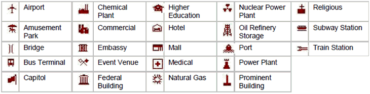
Target Type
Identifies the potential terrorist target nearest the property. The service returns these values: